Introduction
South Dakota (abbr.: SK or S.Dak.), state of the United States of America, 199,552 km2, population 696,000; capital: Pierre.
Fiscal Geography
South Dakota is part of both the Central Lowlands and Great Plains of the United States and is divided into an eastern and a western part by a highland called the Coteau de Missouri. The low eastern part is characterized by low hills and hundreds of lakes. The soil mainly consists of fertile black soil. The higher western part is part of the Great Plains. Far to the west are the north-south running Black Hills (180 km long, 90 km wide); highest point (also in the state) is Harney Peak (2207 m). Southeast of the Black Hills, a landscape has eroded into the fine-grained rock (Badlands), where deep ravines and rocks of fantastic shapes have arisen (Badlands National Park). The main river, which bisects the state approximately in the middle from north to south, is the Missouri. Within the South Dakota area, this river is divided into elongated reservoirs (Lake Oahe, Lake Francis Case and Lewis and Clark Lake) by four large dams to prevent silt transport. The climate has a strong continental character.
Population
The average population density is 3.5 inhabitants. per km2. About 50% of the population lives in urban areas. The largest cities are Sioux Falls and Rapid City.
Economy
South Dakota is one of the most agriculturally retained states in the United States, although industrialization is increasing. Livestock is the main agricultural activity and includes cattle, sheep, pig and poultry farming. The main agricultural crops are maize, wheat, oats, rye and alfalfa. Forestry is concentrated in the Black Hills. Of the – not so extensive – mining, gold mining is the most important; furthermore for oil extraction, sand and gravel, uranium. The main branches of industry are food processing and manufacture of electronic and agricultural equipment; printing industry and publishing houses.
Sights
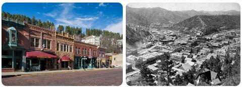
The mountain regions are important recreational areas, with extensive ski accommodation in the Black Hills, among others. There are also a number of parks (including Wind Cave National Park, Badlands National Park) and game reserves (including Custer State Park, Norbeck Preserve). Worth seeing is the Mount Rushmore National Memorial, southwest of Rapid City, where the (20 m high) heads of presidents Washington, Jefferson, Lincoln and Roosevelt are carved into a high granite rock. In the vicinity, since 1948, the Crazy Horse Mountain Carving (170×195 m), depicting Sioux chief Crazy Horse on a horse, has been worked on. Deadwood is home to an old gold mine, historical museums and a number of casinos.
History
Before the arrival of the Europeans, the region was inhabited by several Indian tribes: the Arikara along the Missouri, an agricultural tribe, constantly at war with the mainly nomadic tribes of the Sioux. Dome-shaped burial chambers point to earlier occupation in prehistoric times. In 1742–1743, French explorers, the La Vérendrye brothers, invaded the area, burying a lead slab in the ground as proof of France’s claims to this land (discovered in 1913). In 1794 Truteau, a Frenchman in the service of the Spaniards, traveled north along the Missouri and wintered. In 1804 Lewis and Clark passed through. Now the fur trade began to focus on this area; Pierre Chouteau Jr. took a steamer up the Missouri in 1831 and built a fort on the site of the later capital, which is named after him. The war with the Sioux in 1862 drove out most of the settlers who had arrived at the time. In the winter of 1875–76 there was a gold rush to the Black Hills, which had been promised to the Indians as a residence, which led to a war. In 1889, the Dakota Territory was divided into two states, North and South Dakota (39th and 40th state of the Union, respectively). In 1890, a final war with the Indians was waged at Wounded Knee. The agricultural economy was severely affected by the 1993 floods in the Midwestern United States (around Missouri River).
National Parks South Dakota
Badlands National Park
In 1978 this area was declared a national park, because it has beautiful gorges, small hills and countless gullies. The name Badlands was coined by the Indians and trappers because that’s what they called the dry deep gorges in the highlands of South Dakota. The area has become famous for the discovery of fossils of animals from prehistoric times. Today, the bison is back grazing in Badlands National Park after a long absence. Some other animals that occur are the prairie dog, deer, eagles and hawks. In the summer you have to watch out for the prairie rattlesnake, because this snake is poisonous. The park entrance can be found at the Cedar Pass Visitor Center.
Wind Cave National Park
This park can be found on the southern side of the Black Hills. The park was established in 1903 and takes its name from caves through which a lot of air is pushed by the change in atmospheric pressure. Now and then you can hear a real wind blowing through the cave with a whistling sound. The rest of the park consists of mixed grasses, various wild flower species and a quarter of the park consists of pine forests. Summers are very hot in the park and temperatures can reach up to 35 degrees Celsius during the day and winters are exceptionally harsh. The park is accessible through the town of Hot Springs in the south and through an entrance in the east. You can spend the night at the campsites in the park or in the town of Hot Springs, which also has restaurants.